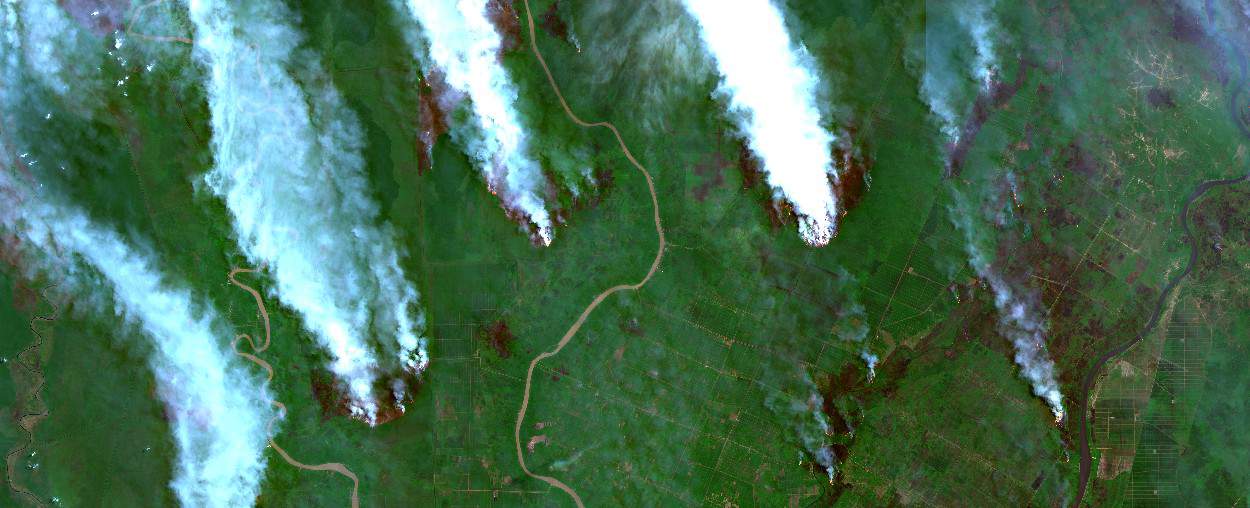
Firefighting efforts are a major challenge in Borneo’s rainforests, where forest fires occur every year. Save the Orangutan is now, in collaboration with DHI GRAS, using satellite data to identify fire risks in vulnerable areas.
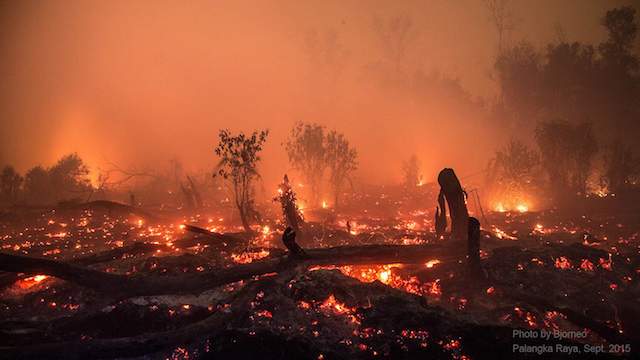
Every year during the dry season, forest fires rage in the tropical rainforests in Borneo, the world’s third largest island. Land areas are often set on fire as a way to clear it for new planting. This harms both animals and people. It also leads to the loss of large rainforest areas.
At Save the Orangutan, we constantly work proactively with our partners to prevent fires. One of the latest tools for this is satellite data. Save the Orangutan and our Indonesian partner BOS Foundation have entered into a collaboration with DHI GRAS, a company with expert knowledge in satellite data.
“With our partners in Indonesia, we have engaged many locals in firefighting patrols. We hope that by improving the use of satellite data, we can strengthen both monitoring efforts from above while also helping to prioritise efforts on ground. In addition, the collected data can be used to document fire risks and illegal logging for the authorities, ” explains Marie Sigvardt, Head of Programs at Save the Orangutan.
Read: Data show significantly increased deforestation rates in Indonesia during corona lockdown
Mads Christensen, Business Development and Project Manager at DHI GRAS, strongly agrees with the potential of satellite data:
“Satellite data is a fantastic tool for documenting the status and identifying changes in regards to environmental work. By analysing this data, we can map forest cover, document changes over time and set up a fire risk model in order to identify the areas that are most vulnerable to fires. It should make it easier to react proactively,” he explains.
The only option to monitor large areas
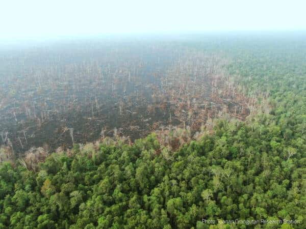
The project initially focuses on the large, partially protected, Mawas area in Borneo. Save the Orangutan’s partner organization BOS Foundation-Mawas, the authorities and other organizations already work hard to prevent fires in the area. However, often it is not possible to react quickly enough when fires occur.
Therefore, improvements in preventive efforts are needed. Satellite data is an important complement to fieldwork and drones.
“The use of satellite data makes it easier for our teams to monitor developments in the field – especially in remote areas that are difficult to reach,” explains Jhanson Regalino, Program Manager for the BOSF-Mawas Conservation Program.
However, the use of satellite data must be tailored to the conditions in the tropics:
“Heavy cloud coverage is often a challenge when making Satellite-based Earth Observations in the tropics. But by using a combination of optical sensors and radar sensors, you can use satellite data as a tool to measure, monitor and identify changes over very large areas – also in the tropics, regardless of weather conditions and time of day,” says Mads Christensen.
Read: Forest fires in the time of corona
Combining technical knowledge and concrete challenges
Satellite data is already a used method by Save the Orangutan and our local partner BOS Foundation’s Mawas Conservation Program.
The monitoring teams in the forest areas use tools such as GPS and drones to collect data and register where fires have occurred and where illegal logging has been detected. However, satellite data can provide many more possibilities. On the other hand, it requires special knowledge to be able to analyse and make optimal use of the data.
“To get the full picture from analysing this data, you have to be an expert. DHI GRAS contributes with that expertise so that the staff in the Mawas area can be trained to get much more out of their satellite data, ” explains Marie Sigvardt.
The collaboration will combine DHI GRAS’s technical expert knowledge with concrete challenges that Save the Orangutan and our Indonesian partners face every day.
“It is quite fantastic when our technical work is used to support specific purposes on earth, such as the battle for orangutans, the forests and the local communities in Borneo,” concludes Mads Christensen.
The project is funded by Civil Society in Development (CISU) and runs until September 2021.